Camping in Death Valley National Park is an experience unlike any other. The desolation of the desert, the unbelievable starry nighttime sky, and the cool temperatures make for an incredible adventure. Though staying in the Oasis at Death Valley may be the better option for those wanting a few more creature comforts, we highly recommend the experience of camping and know you won’t regret it.
Many people will be surprised at the sheer number of camping options that are presented at Death Valley National Park. If you are looking for a place to camp and this is your first time investing the area, it can be a bit intimidating. We hope that our guide will help you navigate through the immense number of choices.
DEATH VALLEY NATIONAL PARK CAMPGROUNDS: OVERVIEW
There are nine total campgrounds in Death Valley National Park, not including the several backcountry sites available. Most are located in the center of the park (near Furnace Creek, Panamint Springs and Stovepipe Wells areas), but there are also campgrounds in the Mahogany Flat area as well as near Scotty’s Castle.
Visitation and camping in Death Valley is most popular in the cooler winter months of the year, as temperature can still stay near the 100-degree mark on a summer evening. Some of the campgrounds are even closed in the summertime.
Reservations are only available at one campground (Furnace Creek), and only in the winter months. The rest of the campgrounds are first-come, first-served. In addition, the Texas Spring and Stovepipe Wells campgrounds are closed in the summer.
The lack of reservations or of open campgrounds shouldn’t scare you-it’s very rare for campers to be blocked out of a campsite. Still, if you want to make sure you get a spot, then making a reservation or arriving before noon will ensure you are able to get a spot at your campground of choice.
DEATH VALLEY NATIONAL PARK CAMPING: SUPPLIES
If you want camping supplies, you have several options. Panamint Springs, Furnace Creek and Stovepipe Wells Village all have groceries and basic goods. If you need something more serious, then we highly recommend making a day-trip to the Las Vegas area (about 2 hours away) or Ridgecrest, CA.
We highly recommend you download our guide for Death Valley National Park. We include all the best places to go, great day-hikes, what drives to take and sights to see while visiting this amazing landscape. Since cell service is non-existent, you’ll want to make sure you have a copy of this ahead of your trip so you can get the most out of your visit!
DEATH VALLEY NATIONAL PARK CAMPING – FURNACE CREEK AREA

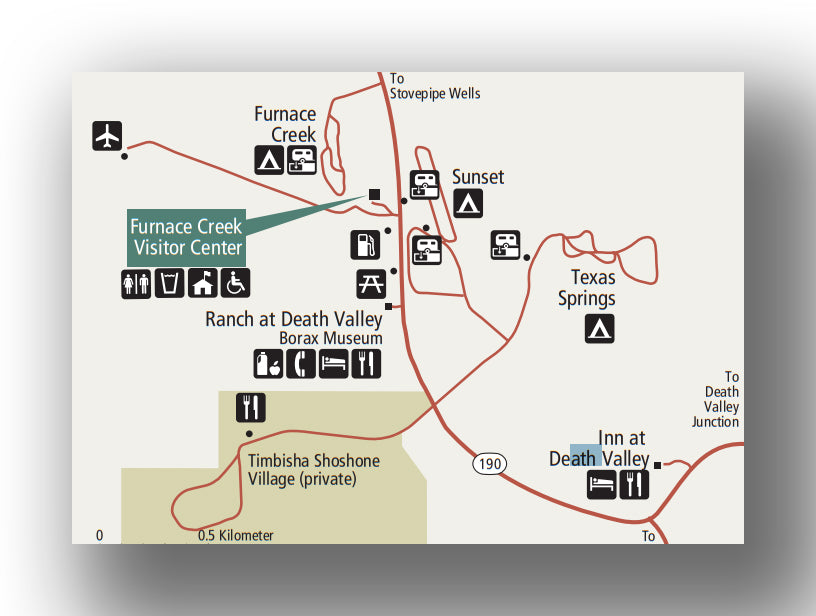
Map of the Furnace Creek Area campgrounds, courtesy of the National Park Service
Furnace Creek Campground:
- Location: The Furnace Creek Campground is located on Highway 190, just north of the intersection with Badwater Road in Furnace Creek. Directions from Furnace Creek to the Furnace Creek Campground.
- Accessible via: Car.
- Reservations: Offered between October 15th through mid-April. Furnace Creek Campground Reservations.
- Capacity: 154 sites.
- Electricity / Water Hookups / Dump Station: Yes / Yes / Yes.
- Toilets / Showers: Flush toilets and no showers.
- Nearby: Furnace Creek is the crossroads of Highway 190 and Badwater Road. If you are in the park for several days, it is a great spot to call home. To the south lies Badwater Road (which is a great drive that can take the better part of a day). To the east is the breathtaking Zabriskie Point and Dantes View and to the north lies Stovepipe Wells and Scotty’s Castle. Immediately around the campground is the Furnace Creek Visitor Center (the largest one in the park) as well as the Furnace Creek store and restaurant.
- Additional details: There are a ton of spots in the Furnace Creek Campground, but it is also the most in-demand campground in the park since it has hookups. If you want to have hookups for your RV, be sure to make reservations well in advance of your stay (6 months if possible).

Furnace Creek Campground map in Death Valley National Park, courtesy of the National Park Service
Sunset Campground:
- Location: The Sunset Campground is located in the heart of Furnace Creek. Directions from Furnace Creek to the Sunset Campground.
- Accessible via: Car.
- Reservations: None.
- Capacity: 270 sites.
- Electricity / Water Hookups / Dump Station: No / No / Yes.
- Toilets / Showers: Flush toilets and no showers.
- Nearby: See the Furnace Creek Campground information above.
- Additional details: The largest campground in Death Valley, the Sunset Campground is a great place to stop. It is essentially a large, paved lot, but there is plenty of space available. If you don’t have reservations and are afraid of not finding a place to stay, this is the most likely spot that you’ll find a spot to camp.
Texas Springs Campground:
- Location: The Texas Springs Campground is located in Furnace Creek, just east of the Sunset Campground. Directions from Furnace Creek to the Texas Springs Campground.
- Accessible via: Car.
- Reservations: None.
- Capacity: 92 sites.
- Electricity / Water Hookups / Dump Station: No / No / No.
- Toilets / Showers: Flush toilets and no showers.
- Nearby: See the Furnace Creek Campground information above.
- Additional details: The Texas Springs Campground is only open in the wintertime and is packed-gravel. There is no shade, but there is plenty of space to spread out at your site. The sites are not private, but that is not a surprise given the landscape. This campground is more in-demand than the Sunset Campground (due to the sites and picnic tables), but both are solid choices.
DEATH VALLEY NATIONAL PARK CAMPING – STOVEPIPE WELLS AREA

Map of the Stovepipe Wells Area campgrounds, courtesy of the National Park Service
Stovepipe Wells Campground:
- Location: The Stovepipe Wells Campground is located on Cottonwood Canyon Road off Highway 190, about 7 miles west of the intersection of Highway 190 and Scotty’s Castle Road. Directions from Furnace Creek to the Stovepipe Wells Campground
- Accessible via: Car.
- Reservations: None.
- Capacity: 190 sites.
- Electricity / Water Hookups / Dump Station: No / No / Yes.
- Toilets / Showers: Flush toilets and no showers.
- Nearby: The most popular spot to visit nearby is the Mesquite Flat Sand Dunes. These are completely different than most parts of the park and is a great place to spot animal tracks in the soft sand. Just south of the campground is the moderately challenging Mosaic Canyon Trail. This 3.5-mile (round-trip) hike heads through a slot canyon before giving way to a great view above the canyon floor (after a 1,000 ft. plus climb).
- Additional details: The Stovepipe Wells Campground is only open in the winter months, but the large number of sites means that if you are in need of a spot this is a great option to consider during the peak months. The campground is essentially a large parking lot without much privacy, but the location is great.
Emigrant Campground:
- Location: The Emigrant Campground is located only 9 miles west of Stovepipe Wells, though to get here you have to climb up out of the valley. Directions from Stovepipe Wells to the Emigrant Campground.
- Accessible via: Car.
- Reservations: None.
- Capacity: 10 sites.
- Electricity / Water Hookups / Dump Station: No / No / No.
- Toilets / Showers: Flush toilets and no showers.
- Nearby: The closest attractions include Mesquite Flat Sand Dunes and the Mosaic Canyon Trail from nearby Stovepipe Wells. Heading south across Highway 190 leads you to the Emigrant Canyon Road, which leads to Emigrant Mine and the Charcoal Kilns.
- Additional details: While only for tents, the Emigrant Campground is a wonderful place to stay as it is 2,100 feet above the valley floor. It is therefore slightly cooler than many of the other campgrounds at sea level, including the nearby Stovepipe Wells Campground. There are also only 10 sites, so you may want to get here earlier in the day if you have a strong desire to stay here.
DEATH VALLEY NATIONAL PARK CAMPING – PANAMINT SPRINGS AND WILDROSE AREAS

Map of the Panamint Springs and Wildrose Area campgrounds, courtesy of the National Park Service
Wildrose Campground:
- Location: The Wildrose Campground is located on Wildrose Canyon Road, just east of where Emigrant Canyon Road turns into Wildrose Road on the western side of the park. Directions from Stovepipe Wells to the Wildrose Campground.
- Accessible via: Car (no longer than 25 feet).
- Reservations: None.
- Capacity: 23 sites.
- Electricity / Water Hookups / Dump Station: No / No / No.
- Toilets / Showers: Pit toilets and no showers.
- Nearby: At the end of Wildrose Canyon Road are the Charcoal Kilns. These were used to make mines in the area and their beehive shapes are quite interesting to view.
- Additional details: Situated 4,100 feet above the valley floor, this campground is located among rolling hills. The scenery here is unlike many of the more conveniently located campgrounds and much more picturesque. You have to put in some time to benefit from the location, though, as it is about one hour from the main road.
Thorndike Campground:
- Location: The Thorndike Campground is located near the end of Wildrose Canyon Road. Directions from Stovepipe Wells to the Thorndike Campground.
- Accessible via: Car (no longer than 25 feet, high clearance).
- Reservations: None.
- Capacity: 6 sites.
- Electricity / Water Hookups / Dump Station: No / No / No.
- Toilets / Showers: Pit toilets and no showers.
- Nearby: In addition to the charcoal kilns, be sure and explore the 8.3-mile (round-trip) hike to Wildrose Peak. It is a good climb, but at the end of the 2,600+ feet gain, you’ll be able to see quite a distance. Since the hike begins already well above sea level, it will be much cooler during all times of year and may even be downright cold.
- Additional details: 7,400 feet above sea level, the Thorndike Campground is truly special. It has shade and can even get snow during some parts of the year. There are only a few campsites, so you’ll have to get a bit lucky to get a spot here if you are going during the busy time of year, but the seclusion is incredible.
Mahogany Flat Campground:
- Location: The Mahogany Flat Campground is located at the end of Wildrose Canyon Road. Directions from Stovepipe Wells to the Mahogany Flat Campground.
- Accessible via: Car (no longer than 25 feet, high clearance).
- Reservations: None.
- Capacity: 10 sites.
- Electricity / Water Hookups / Dump Station: No / No / No.
- Toilets / Showers: Pit toilets and no showers.
- Nearby: See the information on the Thorndike and Wildrose Campgrounds. In addition, the 12-mile Telescope Peak Trail can be accessed from here. This is a hard trail, but leads to the highest peak in the park.
- Additional details: With views of mountains and the Badwater Basin (from over 8,000 feet in elevation), the Mahogany Flat campground is the favorite of many campers and known as one of the best campgrounds in Death Valley. There is also shade in this remote campground and it completely worth the time to get here.
DEATH VALLEY NATIONAL PARK CAMPING – SCOTTY’S CASTLE AREA

Map of the Scotty’s Castle Area campgrounds, courtesy of the National Park Service
Mesquite Spring Campground:
- Location: The Mesquite Spring Campground is located on Scotty’s Castle Road, about 75 minutes north of Furnace Creek. Directions from Furnace Creek to the Mesquie Springs Campground
- Accessible via: Car.
- Reservations: None.
- Capacity: 30 sites.
- Electricity / Water Hookups / Dump Station: No / No / Yes.
- Toilets / Showers: Flush toilets and no showers.
- Nearby: Nearby is Scotty’s Castle (opening in the year 2021 after flood damage), Titus Canyon and Ubehebe Crater. Titus Canyon heads to a ghost town, but is accessible only via high-clearance 4x4 vehicles. Ubehebe Cater is a volcanic crater with great views from the rim (after a short walk).
- Additional details: The Mesquite Spring Campground is one of the more remote campgrounds that is accessible by RV in the park. The sites are packed gravel. Since this is so far away, it tends to be very quiet and offer great night sky viewing. It is also at an elevation of nearly 2,000 feet, making it a bit cooler than the Furnace Creek campgrounds.
DEATH VALLEY NATIONAL PARK CAMPGROUNDS - GROUP CAMPING
Group camping is available at through reservations at the Furnace Creek Campground.
CAMPING OUTSIDE DEATH VALLEY NATIONAL PARK
As stated earlier, there are a ton of campsites in Death Valley National Park. While you may not be able to get your first choice, you shouldn’t have any problem at all. However, if you want to camp outside the park, there are quite a few options, including Beatty, NV (to the northeast of the park) and in Lone Pine, CA (to the west).
If you are looking at boondocking, there is a ton of options for free campgrounds near Death Valley National Park. These sites are perfect if you are looking to be on your own and off the grid.
FURTHER CAMPING INFORMATION FOR DEATH VALLEY NATIONAL PARK
- A great quick reference the National Park website on Death Valley National Park camping. This site provides the latest, up-to-date information on closures and guidelines on camping in the park.
- With the heat and the remoteness of Death Valley, you may be worried about your safety. Tripsavvy.com has a great article on Death Valley National Park camping that is worth checking out ahead of your trip.
- The Ordinary Traveler (Christy and Scott) have a great article on what to do in Death Valley National Park.
FURTHER INFORMATION ON DEATH VALLEY NATIONAL PARK FROM JUST GO TRAVEL STUDIOS
- Our Death Valley National Park itinerary helps take the guesswork out of your planning for your trip to Death Valley.
- For a good overview of what to do in the park, check out our blog on What to See and Do in Death Valley National Park.
- One of our favorite hikes in the area is the hike to the Golden Canyon in Death Valley National Park. Be sure to check out our blog ahead of your trip! In addition, be sure to review our blog on 6 Reasons Why You’ll Fall in Love with Death Valley.
- We also have a great selection of National Park Posters, including our poster of Death Valley National Park.
- After your trip, check out how we can work with you to create a custom, vintage travel poster. We have worked with thousands of customers and would love to work with you!


