Staying in one of the Joshua Tree National Park campgrounds is one of the best parts of the park. They are plentiful, conveniently located throughout the park and all are set in an area that contains incredible scenery.
JOSHUA TREE NATIONAL PARK CAMPGROUNDS: OVERVIEW
There are nine total campgrounds inside of Joshua Tree National Park, making it one of the best camping national parks in the United States. During the peak visiting season (which tends to be November through April), reservations are recommended. Aside from weekends, however, they are really only required during the first few months of each year. This is due to the spring bloom which happens in late February through mid-April (this can vary by year).
Aside from the Cottonwood Spring campground (which is located in the southern part of the park), all the campgrounds are located in the northwestern quadrant of the park.
JOSHUA TREE NATIONAL PARK CAMPING SUPPLIES
As with all camping, it’s best to make sure you have supplies before you enter the park. Once in the park, you are pretty much limited to what you brought with you or what you can borrow from your neighbors. The nearest places to obtain groceries and camping supplies are Twentynine Palms and Yucca Valley to the north and Indio to the south.
Ahead of your trip to Joshua Tree, be sure to download our 12+ page itinerary for Joshua Tree National Park. We cover information on the best hikes in the park, must-see sights, what to pack and what to do ahead of your trip.
JOSHUA TREE NATIONAL PARK CAMPGROUNDS - NORTHWEST
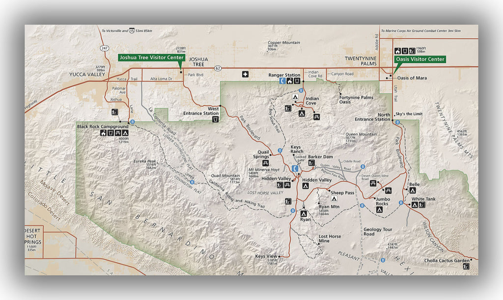
Map of the northwestern area of Joshua Tree National Park, courtesy of the National Park Service
Indian Cove Campground:
- Location: The Indian Cove Campground is located inside Joshua Tree National Park, but it can only be accessed from Highway 62 near Twentynine Palms. Directions from the North Entrance Station to Indian Cove Campground.
- Reservations: Offered only during October through May. Indian Cove Campground reservations.
- Capacity: 101 sites.
- Electricity / Water Hookups / Dump Station: No / No / No.
- Toilets / Showers: Pit toilets and no showers.
- Nearby: The Indian Cove hiking trail starts at the end of the west side of the campground. This is an easy 0.6-mile round trip hike with minimal elevation gain. It is especially nice to take this trail in the morning or evening as the sun is low in the sky, as it produces great color on the cactus. Keep your eyes out for jackrabbits as well!
- Additional details: The campground is surrounded by rock formations, making this a secluded area inside an otherwise flat landscape. There is no water at all in the campground.

Indian Cove Campground map in Joshua Tree National Park, image courtesy of the National Park Service

Belle Campground:
- Location: The Belle Campground is located inside Joshua Tree National Park on Pinto Basin Road, just south of the intersection with Park Boulevard. Directions from the North Entrance Station to Belle Campground.
- Reservations: None.
- Capacity: 18 sites.
- Electricity / Water Hookups / Dump Station: No / No / No.
- Toilets / Showers: Pit toilets and no showers.
- Nearby: Since the campground is in the middle of the park, it is central to almost everything. To the west are most of the park’s sites, but to just to the east is the Cholla Cactus Garden, which is a 0.3-mile trail through amazing cactus (that bloom in the spring).
- Additional details: The Belle Campground is bordered by completely flat desert, giving those that stay here great views of the terrain. It is small and without amenities but quite beautiful.

Belle Campground map in Joshua Tree National Park, image courtesy of the National Park Service
White Tank Campground:
- Location: The White Tank Campground is located inside Joshua Tree National Park on Pinto Basin Road, just south of the intersection with Park Boulevard and south of the Belle Campground. Directions from the North Entrance Station to White Tank Campground.
- Reservations: None.
- Capacity: 15 sites.
- Electricity / Water Hookups / Dump Station: No / No / No.
- Toilets / Showers: Pit toilets and no showers.
- Nearby: There is a small nature trail right nearby the campground. Otherwise, the Cholla Cactus Garden is just to the east.
- Additional details: As one of the smallest campgrounds in the park, the White Tank Campground is never overwhelmed with people and very peaceful. It is in a lightly trafficked part of the park at night, making it excellent for night skies.

White Tank Campground map in Joshua Tree National Park, image courtesy of the National Park Service
Jumbo Rocks Campground:
- Location: The Jumbo Rocks Campground is located inside Joshua Tree National Park on Park Boulevard, just west of the intersection with Pinto Basin Road. Directions from the North Entrance Station to Jumbo Rocks Campground.
- Reservations: Offered only during October through May. Jumbo Rocks Campground reservations.
- Capacity: 124 sites.
- Electricity / Water Hookups / Dump Station: No / No / No.
- Toilets / Showers: Pit toilets and no showers.
- Nearby: Jumbo Rocks is right near Skull Rock, which is a large rock close to the road that resembles a skull. A ton of great hikes are nearby, but all of them are driving distance.
- Additional details: Located right on Park Boulevard, this is a very busy part of the park. However, its location is very convenient making reservations a must.

Jumbo Rocks Campground map in Joshua Tree National Park, image courtesy of the National Park Service
Ryan Campground:
- Location: The Ryan Campground is located inside Joshua Tree National Park just off Park Boulevard, just west of the Ryan Mountain Trail. Directions from the North Entrance Station to Ryan Campground.
- Reservations: None.
- Capacity: 31 sites.
- Electricity / Water Hookups / Dump Station: No / No / No.
- Toilets / Showers: Pit toilets and no showers.
- Nearby: Ryan Campground is located just near the Ryan Mountain Trail, which is the top-rated hike in Joshua Tree National Park. This moderately difficult 3.0-mile round trip hike climbs just over 1000 feet to a 360-degree panoramic view of the surrounding mountains and valley. We covered this trail in our blog on hiking the Ryan Mountain Trail.
- Additional details: Set off Park Boulevard and on the small side, this campground offers a bit more peace than the much larger Jumbo Rocks Campground located just to the east. There are also four designated equestrian sites.

Ryan Campground map in Joshua Tree National Park, image courtesy of the National Park Service
Hidden Valley Campground:
- Location: The Hidden Valley Campground is located inside Joshua Tree National Park on Park Boulevard, near the popular Hidden Valley hiking trail. Directions from the West Entrance Station to Hidden Valley Campground.
- Reservations: None.
- Capacity: 44 sites.
- Electricity / Water Hookups / Dump Station: No / No / No.
- Toilets / Showers: Pit toilets and no showers.
- Nearby: The Hidden Valley campground is nearby a ton of great hiking, including the Hidden Valley Trail and the Barker Dam Nature Trail. It is also just north of Keys View, which is a fantastic place to see sunset. You can read about Keys View in our blog, Keys View in Joshua Tree National Park.
- Additional details: This campground is a winner-many of the sites are secluded (since they are surrounded by large rocks) and hiking and climbing are within walking distance of the campsites. Many campsites are shaded as well.

Hidden Valley Campground map in Joshua Tree National Park, image courtesy of the National Park Service

JOSHUA TREE NATIONAL PARK CAMPING - SOUTH

Map of the southern area of Joshua Tree National Park, courtesy of the National Park Service
Cottonwood Campground:
- Location: The Cottonwood Campground is the only campground located in the remote southern part of Joshua Tree National Park, but with easy access to I-10. Directions from the Cottonwood Visitor Center to Cottonwood Campground.
- Reservations: Offered only during October through May. Cottonwood Campground reservations.
- Capacity: 62 sites.
- Electricity / Water Hookups / Dump Station: No / No / Yes.
- Toilets / Showers: Flush toilets and no showers.
- Nearby: The Cottonwood campground is nearby the Cottonwood Visitor Center, which is worth a stop. Nearby is also the Cottonwood Spring Trail, which is a 0.1-mile walk that leads to shade trees which are great for birding. The more difficult Lost Palms Oasis trail is close as well, but is 7.5 miles long with over 1000 feet in elevation gain (though it is all downhill on the way in).
- Additional details: This campground is popular due to its proximity to I-10, so reservations are recommended. If you are not able to find a spot here, the closest campground is the White Tank Campground, located about 40 minutes to the north.

Cottonwood Campground map in Joshua Tree National Park, image courtesy of the National Park Service
JOSHUA TREE NATIONAL PARK GROUP CAMPING
For details on group camping in Cottowood, Indian Cove and Sheep Pass Campgrounds, refer to the Joshua Tree National Park Group Camping information on their website.

CAMPING OUTSIDE JOSHUA TREE NATIONAL PARK
If you are unable to find a camping spot inside the park, there are a number of campgrounds located outside the park.
Another option is to camp on land managed by the Bureau of Land Management, where camping is authorized for free. Click here for directions from the Joshua Tree National Park visitor center to the Bureau of Land Management land located just north of Joshua Tree National Park.
Don’t expect much in the way of services if you decide to camp here, but there is plenty of room. Be advised that if you happen to go when it has rained recently, the land is known for being muddy and hard to drive through.
FURTHER INFORMATION ON JOSHUA TREE NATIONAL PARK FROM JUST GO TRAVEL STUDIOS
- Joshua Tree National Park is much more than a desert, and you can see exactly what to expect in our itinerary for Joshua Tree National Park. Our itineraries cover places to stay, what to pack and what to do while you are in the area. We also rank each hike to take away the guesswork of how to spend your time while you are in the park.
- Ahead of your trip, be sure to check out our blog on the Best Hikes in Joshua Tree National Park.
- Nearby the Indian Cove Campground is a great trail that you can read about in our blog, Hiking the Fortynine Palms Oasis Trail.
- To see a complete overview of what we did during our visit to Joshua Tree, check out our blog post on Joshua Tree National Park. This can serve as a great guide for what to do if you only have a day in the park.


