Even though hiking in Death Valley National Park may seem like an activity that you may want to intentionally avoid, adventures like the Golden Canyon Trail are outstanding ways to get up close and personal with the desert landscape.
The Golden Canyon Trail is a relatively short hike through a slot canyon. With a gradual elevation gain of just 603 feet, it is terrific for families. We don’t recommend going on the hike in the middle of the day in July (please don’t!). However, if you happen to find yourself in this amazing park in late fall, early spring or anytime during the winter, this hike is fantastic and really gets you “inside” the walls of Death Valley for an amazing experience.
This trail is a perfect choice for anyone looking to stretch their legs. Coming in at just over 3 miles (if you go all the way to Red Cathedral), this out-and-back hike has a very slow incline for most of the trail and is usually not too crowded.
See what you can expect on this easy, and arguably one of the best hikes in Death Valley National Park!
GOLDEN CANYON TRAIL DETAILS
- Difficulty: Moderate
- Distance: 3.1 miles (round-trip)
- Trail: Out-and-back
- Elevation gain: 603 feet
- Peak elevation reached: 613 feet
- Best time of year to hike: Early fall to spring
- To beat the crowds: Arrive before 8:00 am or after 5:00 pm
- Footwear: Sneakers
- Watch out for: Sun exposure
- Restrooms: Located at the trailhead, but not on the trail
- Pets: Not allowed
- Time needed: 1.5 to 2 hours
Things to do in Death Valley National Park, including maps, what to pack for your trip, what to review ahead of time, useful links and information on the best Death Valley hikes (in ranked order), can be found in our itinerary for Death Valley National Park. Internet service in the park is non-existent, so be sure to get your information before you head into the park. Our itinerary can be downloaded and printed to make sure you have what you need, when you need it!
PARKING AND LOCATION FOR THE GOLDEN CANYON TRAILHEAD
The Golden Canyon Trail is located in the Badwater Basin area of Death Valley National Park. From the intersection of Badwater Road and Highway 190 in Furnace Creek (which is the “hub” of Death Valley National Park), take the Badwater Road south for 2.3 miles. The trailhead is located on the east side (left as you head south) of Badwater Road. Directions from Furnace Creek to the Golden Canyon trailhead can be found here.

Map of the Golden Canyon Trailhead in Death Valley, courtesy of the National Park Service
There are only 18 spots in the parking area and the lot can fill up early in the morning (particularly for those who are trying to beat the heat). Frequently, hikers will park alongside Badwater Road as well, though you should check the road signs to verify it is allowed when you are visiting.
There are clean restrooms at the Visitor Center in Furnace Creek. There are also pit toilets located at the trailhead. Unsurprisingly, there are no bathrooms on the trail itself.
HIKING THE GOLDEN CANYON TRAIL TO THE RED CATHEDRAL
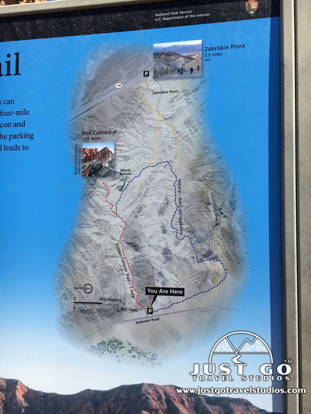
The trailhead is well marked and starts just east of the parking lot. A map of Golden Canyon trail is right at the start of the trail. Ahead of your trip, you can also download a copy of a Death Valley hiking trails map here.


Golden Canyon Trail Map, courtesy of the National Park Service
Immediately after beginning the hike, the trail starts to head up in elevation, but only slightly. In fact, the entire first mile climbs only about 300 feet in elevation.

The trail is quite wide. Since it is in a slot canyon, the wide and contained path makes it easy to keep track of kids of all ages. There isn’t much place to wander off-path!
The aptly named “Golden Canyon” is just that-it’s golden for the entire length of the trail. While this may sound a bit boring, the golden walls against the bright blue sky made for quite the photos during our hike. We even were able to spot some of the rare Death Valley wildlife along the way!


After about 1 mile, the trail comes to a junction with the Gower Gulch Loop Trail. Stay to the left to continue to the Red Cathedral. It is at this point that the trail starts to head up in elevation sharply. Up to this point, the hiking was fairly easy, but it gets more intense from here.

On the last 0.4-mile push to the Red Cathedral, the trail climbs slightly over 300 feet. For this part of the trail, you’ll find yourself climbing over rocks and ducking under boulders. While this was not overly difficult by most measures, it was a bit more of a challenge then we would normally expect for this type of a climb since it was hot during our visit.

THE RED CATHEDRAL
Once the trail climbs to the Red Cathedral, you will be surrounded by high rock formations that are red in color. This is quite the different landscape than is seen in most of the park.


While there aren’t any amazing overlooks, it is possible to catch a glimpse of a few extended views, particularly on the way down.

THE RETURN TRIP
The trip back to the parking lot goes quickly, since it is all downhill. We found that we took about 10 minutes less heading back, and our kids who were tired on the way out ran back most of the way without stopping!

ZABRISKIE POINT HIKE AND HIKING THE GOLDEN CANYON GOWER GULCH LOOP
As mentioned earlier, the Golden Canyon Trail meets up with the Gower Gulch trail about one-mile into the hike. If you want to have a slightly longer hike back, you can continue on the Gower Gulch Loop, which increases the total hike to about 4.2-miles. This trail offers stunning landscape scenery.
Another option is to continue the hike to Zabriskie Point. After taking a right, passing the Manly Beacon (a rock peak) and walking 0.8 miles, the trail meets up with a junction. Heading to the right takes you back on the Gower Gulch Loop, but turning left takes you the 1.1 miles to Zabriskie Point. Zabriskie Point is a stunning viewpoint that has colors like you would never expect in Death Valley National Park.
FINAL THOUGHTS
- The Golden Canyon Trail is one of the best Death Valley hikes for families. It’s the perfect combination-the easy slope, the unexpected Red Cathedral at the end and the interesting landscape make it perfect.
- Additionally, the trail offers options to continue farther if your group is feeling up to it. The optional hike to Zabriskie Point or continuing for the full Gower Gulch Loop are great to have. It also means that if you want to hike from this trailhead more than once during your visit that there is plenty of variety.
- It is critical to come here prepared. Make sure that you bring plenty of water with you. You should fill up your water at the Furnace Creek Visitor Center and make sure you carry plenty of extra in the car. Sunscreen is required as well as a hat and sunglasses.
- While the trail is fairly well marked, we found ourselves wanting to learn about the landscape. Additionally, it’s not uncommon for us to take a different trail than we originally planned just because we may be up for hiking more / less than we thought we would. Because of this, we strongly recommend carrying the National Geographic Map for Death Valley National Park. These maps are durable and contain topographical information to help you know where you’re going at all times.
FURTHER INFORMATION ON DEATH VALLEY NATIONAL PARK FROM JUST GO TRAVEL STUDIOS
- In our itinerary for Death Valley National Park, we cover a ton of information to help you get started on your trip planning for Death Valley. This pin will also give you a quick overview of the park.
- We cover Death Valley National Park extensively in our blog, What to See and Do in Death Valley National Park. We also have some great information on Camping in Death Valley. Be sure to check it out ahead of your trip!
- We covered things to do in Death Valley National Park in detail in our blog 6 Reasons Why You’ll Fall in Love with Death Valley National Park. We were really impressed with Death Valley and believe you will be too. You’ll have to check out the picture we had from our visit when the Superbloom was going on!
- When you get back from your trip, we’d love to work with you to create vintage-style travel posters from photos. You send us a photo and we’ll work with you to customize the wording and look and feel to make your poster just right.
OTHER USEFUL LINKS ON DEATH VALLEY NATIONAL PARK
- Tim and Julie (from “Earthtrekkers”) have a terrific article on a much more challenging hike for those of you who have adventurous families. The Grotto Canyon Hike in Death Valley can be quite exciting, and is worth a look! You need to check out the climbing that you have to do on this trail, and their family rocked it!
- Esther and Jacob (from “Local Adventurer”) have some great photos and information about nearby Mesquite Flat Sand Dunes.
- Johnny (from “Johnny Africa”) has a terrific road trip itinerary that combines Death Valley, Joshua Tree and the Red Rock Canyon. This is a great template for a five-day vacation!


