If you are visiting this amazing region of Oregon just east of Salem and Portland, then you have to go hiking in Silver Falls State Park! Not only are the hikes here both fun and not overly challenging (for the most part!), you are also guaranteed to have some incredible waterfall views like you can only get in Oregon. Plus, where else can you go on a single day hike and see 10 amazing waterfalls!
We put together our list of all the hikes you should consider doing in Silver Falls State Park. They range from short and flat hikes that are great to do after dinner at the Silver Falls State Park campground, to day-long hikes that see most of what there is to see in the park. We’ll provide trail maps, difficulty ratings, elevation gain and distance as well as a bit of information about the details of each of the trails. We’ll also cover what you need to know about getting to each trailhead.
HIKING IN SILVER FALLS STATE PARK: PREPARATION
Hiking in Silver Falls State Park is a bit different than most parks in the country. First of all, bugs are rarely an issue in Oregon. The other big difference is the amount of water on this trail. You will get wet. While it can be refreshing, it also can be downright cold, so you need to be prepared with a few things in particular:
- Since the trails are wet, you need to have footwear that is grippy in the rain and will protect your feet. We recommend hiking boots, but any footwear with good grip is recommended.
- You need to have waterproof clothing or rain gear. This part of the country is frequently wet (the waterfalls have to get water from somewhere!) and rain is common, plus you’ll be passing near waterfalls likely and will appreciate some protection from the water.
- We highly recommend bringing a couple of layers in case you get cold. The hiking here can get quite frigid if you combine the cold air with water, and it can be a bit dangerous if you don’t have the ability to get warm.
- Finally, and this is something that you should really think about, is that the hikes here can get crowded. Like really busy. So you may want to get to the park early in the morning to get your hike started, particularly on the Trail of Ten Falls hike.
HIKING TRAILS IN SILVER FALLS STATE: TRAIL DESCRIPTIONS AND TRAIL MAPS
TRAIL OF TEN FALLS
- Difficulty: Moderate
- Distance (round-trip): 7.2 miles
- Elevation gain: 1180 feet
- Hiking time (approximate): 4 hours
- Trail type: Loop
- Potential hazards: Wet and slippery trails
- Restrooms: Flush toilets are located at the trailhead (at the South Falls Day Use Area). There is a pit toilet North Falls Trailhead on the east side of the hike.
- Recommended footwear: Hiking shoes or hiking boots.
- Pets: Not allowed. Note: pets are allowed on the Rim Trail portion of the hike, provided they are on a leash.

Trail of Ten Falls Trail map, courtesy of Oregon State Parks
Trail Description
If you can only do one hike in the park, do this one! This trail features a hike along the rim of the canyon and takes you by 10 waterfalls!
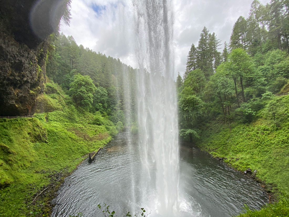
You can start the trail either way, but we recommend heading to the left (west) side so as to have a gradual climb during your hike. The hike starts off by descending fairly steeply for the first 1.7 miles. Shortly after departing the trailhead you’ll come across South Falls. Perhaps one of the most impressive spots on the hike, South Falls drops 177 feet.
You’ll continue down in elevation as you approach Lower South Falls. This 93 feet waterfall is reached after using a set of switchbacks. You’ll actually hike on the back side of it, offering you an amazing view that most don’t see with waterfalls!
The trail stops descending at the 1.7-mile point and then starts the slow but long climb back up to the canyon rim. You’ll then pass by Lower North Falls and hit the short spur to Double Falls.
After visiting Double Falls, you’ll retrace your steps briefly before heading back to the south and quickly coming up on Drake Falls and Middle North Falls, which is another waterfall that you get to pass behind on the trail. Dake Falls is small (only 27 feet) but Middle North Falls drops 106 feet.
At the 3.1-mile point you are faced with a decision-head back and skip the longer part of the loop to the east or continue on. If you turn here and head south it cuts off about 2.2-miles of the hike.
If you continue to the east, the trails comes up on Twin Falls. While only 31 feet high, the falls split making two incredible streams of flow during the wetter months.
Continue east for another mile and you’ll come up to North Falls. You’ll pass behind the falls once again and then hike out of the canyon.
There is a restroom at the 4.4-mile point before you head to the east for about 0.4-miles and come up to Upper North Falls. The waterfall is relatively short (at 65 feet) but beautiful during high flow months.
Trace your steps back to the west and then head left when you get to the trail junction (just after passing underneath the highway). You’ll then be able to see North Falls again from a viewpoint, which is a different perspective. Keep continuing and at the 6.2-mile point you’ll get to Winter Falls. The trail to this point along the rim is relatively flat, and then continues as a flat trail until you get close to your starting point, when it descends slightly.
Note-Pets are allowed on the Rim Trail portion of this hike.
Trailhead Directions
The trailhead starts at the South Falls Day Use area, on Highway 214. You can also pickup the trail on the east side of the park at the North Falls Trailhead or the North Falls Day Use area. Parking can be limited on busy days, so be sure to get here early.

SOUTH FALLS AND MAPLE RIDGE LOOP TRAIL
- Difficulty: Moderate
- Distance (round-trip): 2.6 miles
- Elevation gain: 400 feet
- Hiking time (approximate): 1.5 hours
- Trail type: Loop
- Potential hazards: Wet and slippery trails
- Restrooms: Flush toilets are located at the trailhead.
- Recommended footwear: Hiking shoes or hiking boots.
- Pets: Not allowed.

South Falls and Maple Ridge Loop Trail map, courtesy of Oregon State Parks
Trail Description
If you don’t have time (or the energy) to do the full Trail of Ten Falls, then this is a fantastic option. After leaving the South Falls Day Use area, you descend into the canyon and pass by South Falls. The trail continues to Lower South Falls. Once you get to the 1.4-mile point, turn right onto the Maple Ridge Trail. The hike ascends steeply out of the canyon, aided by switchbacks.
The Maple Ridge Trail traverses along the ridge of the canyon until you get back to the start of the hike.
This hike is quite a bit shorter than the Trail of Ten Falls and you can see some amazing waterfalls. Be prepared, though, as this hike is one of the busier ones in the park as it is relatively short while still offering some of the best views of the waterfalls in the park.
Trailhead Directions
The trailhead starts at the South Falls Day Use area, on Highway 214.

BUCK MOUNTAIN LOOP
- Difficulty: Moderate
- Distance (round-trip): 8.0 miles
- Elevation gain: 1045 feet
- Hiking time (approximate): 4 hours
- Trail type: Loop
- Potential hazards: Wet and slippery trails, mud and bugs
- Restrooms: Pit toilets are located at the trailhead. There are no toilets on the trail.
- Recommended footwear: Hiking shoes or hiking boots.
- Pets: Allowed, but must be kept on a leash six feet or shorter at all times.

Buck Mountain Loop Trail map, courtesy of Oregon State Parks
Trail Description
If you want a trail that gets you away from crowds, this is it! After leaving the trailhead, head east. At the 0.6-mile point you’ll reach a fork, which you can take either way. We recommend taking the trail to the left to give you a smoother uphill climb, which lasts through mile 4.0. At 3.3 miles, the trail turns toward the south and then starts to head back west.
The hike starts to descend slowly back to the trailhead, with it only getting steeper when you have about one mile to go until you return.
This trail is frequented by horses and mountain bikes, so it can get a bit muddy. During the entire hike you are traveling through an old growth forest full of evergreens and mosses, making it quite pretty and lush in the summertime.
The trail is very quiet, as most of the people visiting the park are here for the waterfalls.
Trailhead Directions
The trailhead starts just to the southeast of the Silver Falls State Park campground at the Howard Creek Trailhead.
HOWARD CREEK TRAIL
- Difficulty: Moderate
- Distance (round-trip): 3.7 miles
- Elevation gain: 305 feet
- Hiking time (approximate): 2 hours
- Trail type: Loop
- Potential hazards: Wet and slippery trails, mud and bugs
- Restrooms: Pit toilets are located at the trailhead. There are no toilets on the trail.
- Recommended footwear: Hiking shoes or hiking boots.
- Pets: Allowed, but must be kept on a leash six feet or shorter at all times.

Howard Creek Trail map, courtesy of Oregon State Parks
Trail Description
The Howard Creek Trail is a great option if you’d like to have a relatively flat trail through the woods without taking up too much time. This is a great trail run if you are into that as well!
Start by heading east from the trailhead. Take a right at the first and second junctions to stay on the Howard Creek Trail. The rail winds south until it gets to the Silver Falls Lodge. Cross through the parking area and pickup the trail again as it heads to the north along the road and back to the trailhead.
The hike is peaceful and usually pretty quiet, but be advised that it can be muddy.
Trailhead Directions
The trailhead starts just to the southeast of the Silver Falls State Park campground at the Howard Creek Trailhead.
SILVER FALLS NATURE TRAIL
- Difficulty: Easy
- Distance (round-trip): 1.1 miles
- Elevation gain: 30 feet
- Hiking time (approximate): 30 minutes
- Trail type: Loop
- Potential hazards: Mud
- Restrooms: Flush toilets are located at the trailhead (at the campground).
- Recommended footwear: Hiking shoes or hiking boots.
- Pets: Allowed, but must be kept on a leash six feet or shorter at all times.

Silver Falls Nature Trail map, courtesy of Oregon State Parks
Trail Description
This is a short trail that is a perfect option if you are looking to stretch your legs after dinner at the campground. It’s quiet and well maintained. You can also use this trail as a connecting route to the 214 trail.
Trailhead Directions
The trailhead starts at the Silver Falls State Park Campground.
Additional smaller trails are also available, as well as a myriad of connections with other trails to make up your own routes.
ARE PETS ALLOWED ON THE TRAILS AT SILVER FALLS STATE PARK?
Pets are not allowed on the Trail of Ten Falls, but they are allowed on all other trails in the park. Pets are allowed on the Rim Trail portion of the Trail of Ten Falls.
On trails where pets are allowed, they must be kept on a leash of 6 feet or less at all times.
WHEN IS THE BEST TIME OF YEAR TO HIKE IN SILVER FALLS STATE PARK?
Without a doubt, the best time of the year to hike in Silver Falls State Park is the summer. The falls are flowing well and the temperatures are warm enough so that the water and spray feels refreshing. In the spring and fall it can be quite cold on the trail.
HIKING IN SILVER FALLS STATE PARK IN THE WINTER
Hiking in Silver Falls State Park in the wintertime is magical. The falls are still flowing, but the water that they flow into is commonly frozen. Be sure to bring microspikes and plenty of warm gear. You will get wet, and the cool air can make you hypothermic if you are not prepared.
FURTHER INFORMATION ON SILVER FALLS STATE PARK FROM JUST GO TRAVEL STUDIOS
- If you are coming to Silver Falls State Park and plan on staying here, check out our blog on Camping in Silver Falls State Park. Also check out our blog on Things to Do in Silver Falls State Park.
- After you finish up with your trip to Silver Falls State Park, send us a photo or two and we’ll create a custom, vintage-style poster!